
People of the sky, let’s talk about weather! More specifically, how do YOU look at the local flying forecast? What sites do you go to, what do you look for on them, and how often do you check?
Weather’s one of those things that starts to matter once you figure out how to keep your wing above your head and being to dial in your site flying. As you start to make your own calls about which site you’ll fly, getting a feel for what all the numbers mean along with the best way to read the data for you, begins to be important.
I’ll start with Chris Cote, one of our local XC hounds. He realized early on that cross country flying would take more than skill with a wing and he dove deep into understanding the weather. He generously went through a screencast of what he looks at and why, which you can see here:
I’ll start with Chris Cote, one of our local XC hounds. He realized early on that cross country flying would take more than skill with a wing and he dove deep into understanding the weather. He generously went through a screencast of what he looks at and why, which you can see here:
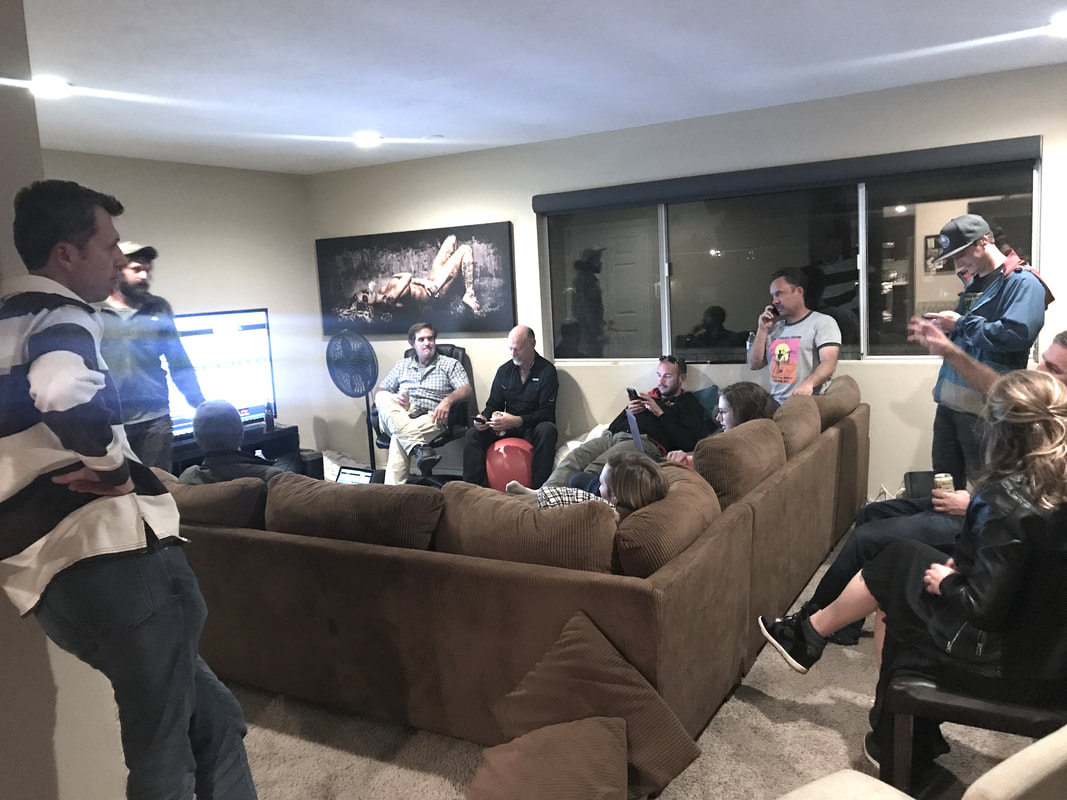
Bill Davis recently held an informal weather talk over at Tony B’s house on a Friday night and about 80% of our local active pilot population showed up. Sheesh, I guess that tells you about local pilot priorities.
Bill repeated Chris’ points about looking at many models to gather a ton of data and validate each other, and also mentioned the importance of separating hard data from models. No matter what the Windgrams say, if MesoWest shows it’s blowing 30 knots in the other direction…pay attention to MesoWest!
Ok, let’s walk through Bill’s flow:
Bill starts on the SDHGPA Weather Dashboard, which you can find here.
Bill does a quick overview scrolling through the whole thing, just absorbing the data at a high level without getting into the details. The first question is always: Is this a day worth flying?
He then focuses in on the Windgrams section in the SDHGPA Weather Dashboard.
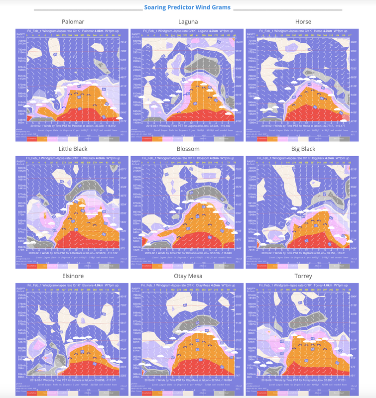
He asks himself the following questions:
-What is the site elevation vs cloud base?
-What is the wind direction? In San Diego, where we “fly the wind” as well as the sun, wind direction is important for many local sites.
For example, Otay works best with a South wind, while Blossom and Little Black work best with West winds. Read through the site guides to figure out what wind direction will best suit the site you want to fly.
-What is the wind speed at the surface along with up at elevation? Elevations above where we fly can still have an impact on the weather below.
-How high is cloudbase?
After checking the WindGrams on the WX Dashboard, Bill scrolls up and digs into the RASPtable.
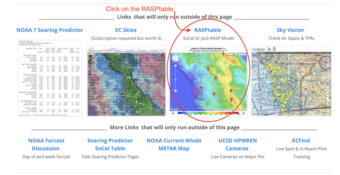
RASP stands for Regional Area Soaring Predictions and is built for us free flight pilots (unlike most “standard” weather models which cater to folks flying things with engines. Like 747s.
Bill's RASP Set Up
Bill's RASP Set Up
- Living here in San Diego, Bill usually starts off by selecting the “South Area” to only view sites he’s likely to drive to and fly.
- He’ll check the dates to make sure the data is coming from today; sometimes there’s lag in data loading. Making a decision for today’s flying based on yesterday’s data can be…frustrating. Yes, the details are important.
- He’ll choose the 1.3Km resolution
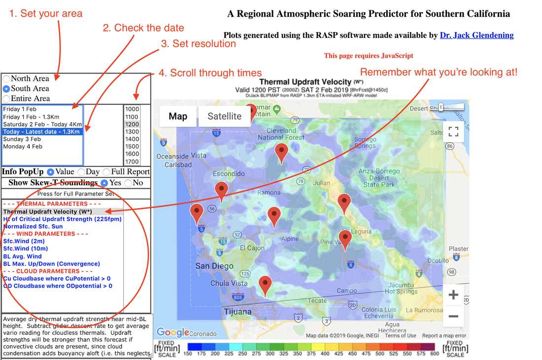
After setting it up so it’s showing where, when, and how he wants it, he’ll start scrolling through the RASP Parameters, checking times throughout the day.
He looks at the SFC (surface) winds over the flyable day, anywhere from 10 AM to 6 PM depending on the season. He’ll check the BL Max Up/Down (Convergence) to where convergences might set up. BL stands for Boundary Layer. You can check out all the terms for the RASP table at this link.
Bill looks at Cu Potential (Cu = Cumulus) to check cloud development, what time it’s expected to develop, and how widespread it will be.
He looks at OD potential especially during summer convergence flying. He'll use that along with cloud info on XC Skies just to know how the day will develop and if he needs to be concerned about OD and the hazards that comes along with it.
He’ll zoom out and look for convergence lines; usually we’ll see one in San Diego setting up over East County, from Pine Valley up through Laguna, to Julian and north. This is a classic XC route for pilots Spring through Fall.
Once he’s got a general idea for the day, Bill will click on a specific site he’s interested in to pull up the Skew T.
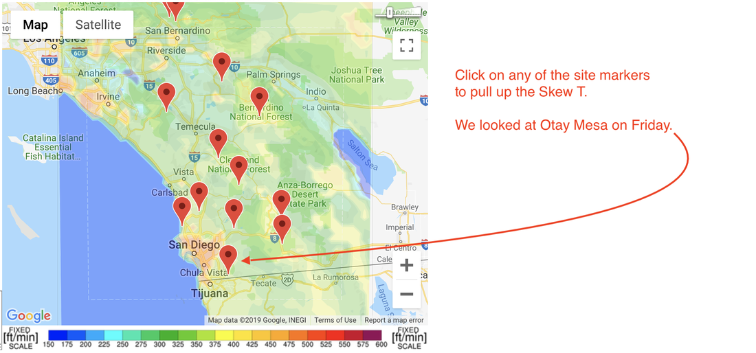
The Skew T chart gives us temperature, dew point, along with wind speed & direction at all flyable elevations. Be aware that for these site charts they represent *model* data. They’re based on only one weather balloon that goes up from Miramar really early in the morning and late in the afternoon here in San Diego. While it’s usually accurate, it’s not *actual* data.
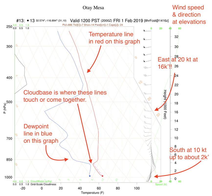
Want to learn how to really read a Skew T rather than hope my notes are enough? Check out Abe Heward’s rad little guide on reading a Skew T for paragliders, here.
Once Bill’s checked out the Skew T, he has a pretty good idea of what the general area looks like and what his specific “picked” site might deliver.
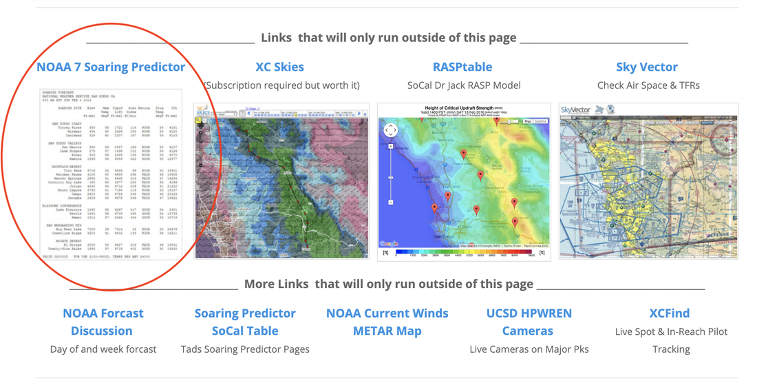
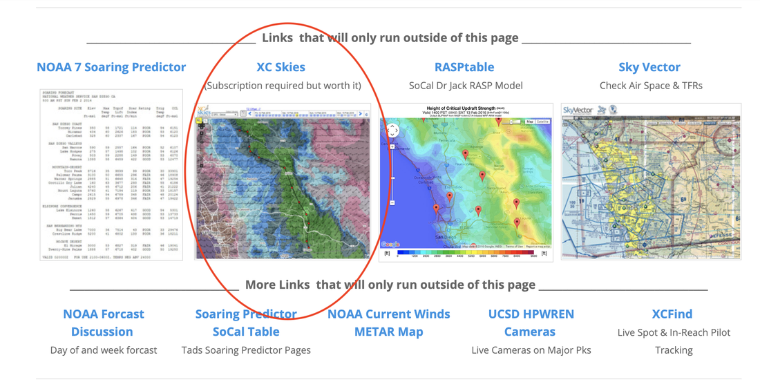
He then checks that information (remember to cross-check models in order to validate what you think you’re seeing!) on the NOAA 7 Soaring Predictor (from the SDHGPA Weather Dashboard.)
Once Bill’s checked out the Skew T, he has a pretty good idea of what the general area looks like and what his specific “picked” site might deliver.
He then checks that information (remember to cross-check models in order to validate what you think you’re seeing!) on the NOAA 7 Soaring Predictor (from the SDHGPA Weather Dashboard.)
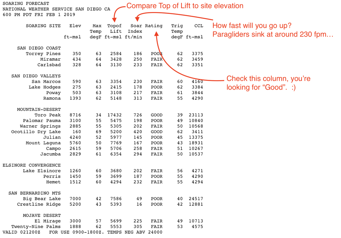
He’ll look down all the columns to re-check what the day might be like. He’s focusing in on the Ratings, looking for “Good”. He’s also checking the Top of Lift and comparing it to the elevation of launch at the site as well as the Soar Index and make sure he’s seeing something more like 400+ fpm and not, say, 100 fpm. Ahem! Cough [Amber].
Finally, he’ll open up XC Skies, which is a paid subscription (as of 2019, $40/year.) He’ll look at the NAM3 and the HRR3 for US sites, and the GFS30 if he’s overseas.
I’m going to leave the XC Skies flow for another blog post.
At the end of Bill’s presentation, I asked a few of our most enthusiastic weather guessers for their flow. Here’s how they roll. It’s worth noting that while Bill uses primarily a desktop computer, all of the following pilots rely mainly on their phones and apps. I’ve included a list of all the links to these at the bottom of the page.
Brad Stevenson: Windgrams, Windy, looking through all the times and altitudes.
Ethan Vance: Windgram, RASP, going outside and looking at the sky, XC Skies, US Air Net if he’s outside of SD.
David Hatfield: Windgrams, Windy (on a desktop) looking at all altitudes, XC Skies, Flow X for clouds.
Chris Ottmar: Weather Underground, Soaring Predictor, Windy, XC Skies, Wind Alert, then on desktop he’ll look at HP Wren cameras and the GOES16 for water vapor in the atmosphere.
Ottmar had an additional point regarding thinking about where the clouds might be coming from vs. the angle of the sun and time of day.
If the clouds are coming from the North and you’re flying a site in winter, you may not have to worry until much later about thermal heating being cut off by clouds since the clouds will take longer to get to a point where they shade you out. Wizard thinking, Chris!
The secretive agent "Red Squirrel" declined to provide his weather guessing flow beyond stating "The area forecast is useful for skiing." No further information was extracted from this recalcitrant asset.
Weather Links & Pages used by local SD Pilots beyond or in addition to the SDHGPA Weather Dashboard
Windgrams
Windy
RASP
XC Skies
US Air Net
Flow X
Wind Alert
Soaring Predictor
HP Wren Cameras
GOES16
Windgrams
Windy
RASP
XC Skies
US Air Net
Flow X
Wind Alert
Soaring Predictor
HP Wren Cameras
GOES16
Chris Cote's Additional Weather Tabs:
NOAA Surface Analysis
NWS Area Forecast Discussion
Skew T from Miramar Balloon
Jetstream
SDHGPA XC Route Cameras (HP Wren)
MesoWest
NOAA Surface Analysis
NWS Area Forecast Discussion
Skew T from Miramar Balloon
Jetstream
SDHGPA XC Route Cameras (HP Wren)
MesoWest
That should set you up for figuring out your own weather prediction flow, feel free to comment below with any updates or edits. Any mistakes are mine alone. :)
-NFH@SDHGPA
-NFH@SDHGPA

 RSS Feed