
Laguna Mountain Flying Report 3, May - Bill H
Shallow Convergence & Westerly Flow Cut-off Effects
Saturday turned out to be a great Laguna day. Andy, Anna, John, Mike and I were set up and ready to go by 11:30. We were all in the air by 12:15. It was probably blowing down by 1:00. The sky was clear blue, not a cloud in sight.
The convergence thermals were just behind launch and in a few minutes Mike and I were over 10,000'. I followed Mike to Granite, never getting lower than 9,400'. At Granite thermals were good, climbing to near 11,000', and the wind was light from the East. I headed West thinking that I would run into "the convergence" and find even better lift. The air was stable and I was slowly losing altitude.
A few miles West of Granite I was at 9,000' and still in a light East wind. It just didn't seem right somehow, so I headed back towards Granite then North to the Volcans. I arrived at the South end of the Volcans at 8,000'. Mike was a few hundred feet above me. Still in a light East wind, so continue along the Volcans, lift has to be here somewhere.
Then at 7,500' the wind was West at 12 mph. I told Mike I was going to head across San Felipe Valley to the San Felipe Hills. The air was flowing down, even with a 12 mph tail wind my glide over the ground was only 3.5 to 1. I arrived at the Fish & Game lz with just enough altitude to verify the West wind and land.
Mike had a little more altitude and was able to get to the San Felipe hills and work the weak lift. Andy reached 12,000' on Granite and headed to where Mike was. The lift was too weak and the drift to the East was too much for Andy and he came out and landed at Fish & Game. Mike stuck with the lift and finally made it to the convergence thermal over Ranchita. Anna and John were a few minutes behind Andy and found nothing at Granite. They headed East over Earthquake Valley.
Anna was down to 3,000', 500' agl, and getting ready to land. A few birds drifted by, not far away, and climbing. She followed them and soon was over 11,000'. Now that's a thermal. John also found the lift over Earthquake Valley and they headed Northerly toward Ranchita and then Coyote Peak.
Mike, John and Anna were now no longer in the convergence thermals. (That line probably went North from Ranchita toward Toro Peak. Driving through Borrego Springs mid afternoon we saw dust devils between Coyote Peak and Coyote Canyon.) They were able to get close to 9,000' on Coyote Peak, then again on the Santa Rosas. They went on glide North and landed just West of Thermal Airport for 52 miles or so.
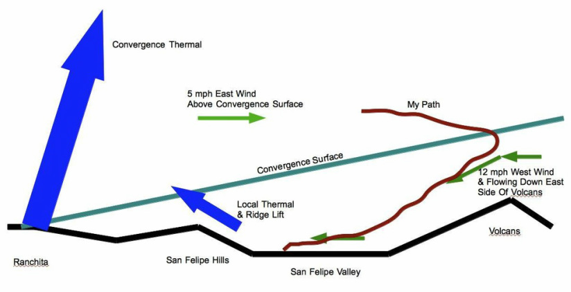
Drawing of my interpretation of what was going on. I think the convergence surface was leaning very shallowly up and to the West. The convergence thermals were starting near the ground location of the convergence and going almost straight up. Sometimes the convergence surface is near vertical. That and clouds make flying the convergence a little easier.

 RSS Feed